New Zealand was warned 35 years ago about the effects of deforestation of hillsides, draining of wetlands and building behind stopbanks, a freshwater expert says.
Forest & Bird freshwater advocate Tom Kay read examples of the warnings from a post-cyclone report at a panel discussion at Whakatāne Little Theatre last week, attended by about 100 people.
“Deforestation of hillsides has greatly accelerated widespread erosion. Afforestation (the planting of new trees) of the hill country probably represented the only economically viable erosion control option”.
“Unwise intensive development behind stopbanks has often been encouraged. We’re too reliant on stopbanks that have given people a false sense of security”.
The report also stated: “Draining of wetlands has intensified flooding problems in many areas”.
It was written in 1988 by New Zealand’s first Parliamentary Commissioner for the Environment Helen Hughes and summarised the findings of an inquiry into flood mitigation measures following Cyclone Bola.
“The one lesson we took was that we should put forests back,” Kay said. “But we put pine forest on very steep hill country and then we clear felled that forest.
“The lesson we need to learn this time is … native forest needs to be our main focus on that hill country – and it needs to be quality native forest. We need to be doing pest control so that [the forest is] actually doing the job that it used to do.”
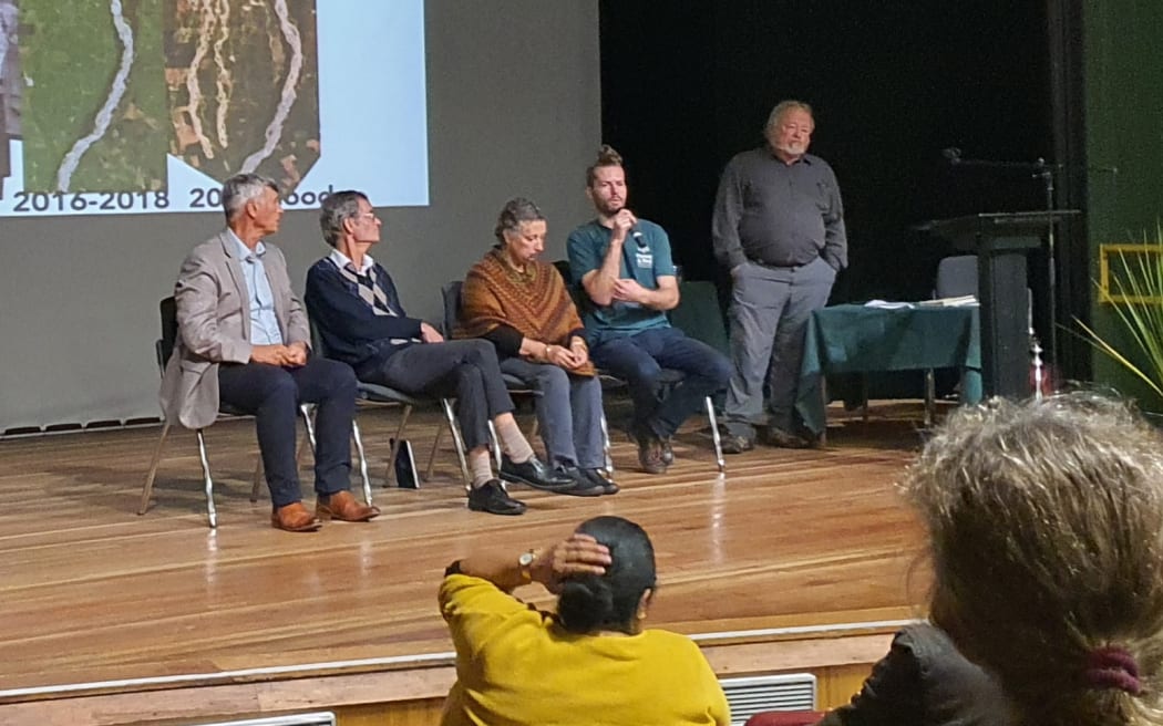
(From left) Bay of Plenty Regional Council chairman Doug Leeder, environmental engineer Peter Askey and sociologist Mawera Karetai joined Forest & Bird freshwater expert Tom Kay for a panel discussion with former regional councillor Bill Clarke as MC. Photo: Supplied/ Local Democracy Reporting/ Diane McCarthy
Kay also read from a report written last year by a group of river experts, called Reanimating the Streams and Rivers of Aotearoa New Zealand.
“They concluded that working against nature does not work. We may inadvertently be manufacturing future disasters.
“And moving out of harm’s way saves lives,” he read.
Kay, who grew up in Napier, spoke first about his own family’s recent experience during Cyclone Gabrielle flooding.
Now living in Wellington, he recalled watching the flow gauge for the Tūtaekurī River on the Hawke’s Bay Regional Council website on the morning of 14 February, as Cyclone Gabrielle was “smashing the region”.
“I was refreshing the regional council website, trying to figure out if the river was still rising or falling, because my family lives just downstream from the gauge in Taradale, about 600 metres away from the stopbank.”
He said the river was flowing at more than 1800 cubic metres per second when the gauge failed.
“That’s 1800 tonnes of water flowing past a single point every second. It probably got higher than that.”
His family got off lightly compared to the “massive devastation” others in the region suffered, having their homes yellow-stickered.
While acknowledging that flooding at various places throughout New Zealand in the past couple of years had been caused by extreme weather events due to climate change, he said it was also how we managed our environment that led to flooding.
The country had lost 90 percent of its wetlands, “which are those sponges in the landscape that absorb water during heavy rain and slowly release water during droughts. We’ve cleared the forests and introduced pests to those forests that are left – which means that those forests don’t absorb water like they used to.
“We’ve severely modified the rivers of our plains. We’ve straightened them, hemmed them in. We were trying to get the water out to sea as quickly as possible, to drain the landscape.”
Kay showed a series of aerial photos of rivers from many places throughout New Zealand, both historically and how they look in the present day, showing how they had been changed from “meandering, rippling, pooling,” braided rivers, hundreds of meters wide in places, to straight canals.
He compared them to photos taken after flooding, where the river had returned to its historic paths.
“We have created a false sense of security. We’ve got rivers perched up above their flood plains and we’ve built right up next to the stopbank.
He showed examples of projects both internationally and in New Zealand where stopbanks had been set wider apart to allow for wetlands, riparian areas, and more space for the river to self-adjust.
The Netherlands, the country most associated with engineering of waterways, was leading the world in this work, he said.
The panel discussion was one of many Forest & Bird events being held throughout New Zealand to celebrate the organisation’s centenary.
Eastern Bay Forest & Bird spokesman Mark Fort said the event was a great success and it was great to see people networking and talking after the event.
What the panel said
Bay of Plenty Regional Council Chairman Doug Leeder said it was important the discussion was taking place, and agreed higher stopbanks were not the answer.
“It’s absolutely invaluable and as far as the regional council goes, it’s our bread and butter stuff in terms of trying to address the issues that Tom’s put in front of you. I wouldn’t disagree with one thing that he has said.
“If we think we can keep going higher and higher, we’re kidding ourselves. So, it’s what we do, going forward, that is the critical thing that we need community input about.”
Leeder said the regional council was having conversations with landowners further up the catchments across the Bay of Plenty about allowing the river to go wider.
“Some of those people have big investments. Some people along the Whakatāne River, up here in the Tūhoe country, they’re losing hectares of their land every year from erosion, from the extra volume and the speed of the waters coming down.
“Those people are reluctant to let that go, but it’s a hard conversation we’ve got to have with them.
“The regional council is out there. We’re doing this. There’s not one size that fits all, but catchment by catchment we’re moving around the communities to endeavour to address some of the issues that Tom’s put in front of you.”
Another panelist was environmental engineer and farmer Peter Askey. He has spent his career of more than 40 years working on systems such as river controls, stormwater and culverts, and has farmed alongside his family, who have worked the Bay of Plenty’s Rangitāiki Plains for more than 70 years.
He said New Zealand needed to get the balance right between providing space for our rivers and maintaining our way of life.
“The concept of making room for rivers is great. I’m sure you’ll all agree with that, until it’s your place that you’ve been asked to move – to give up your land, your farm, your whenua, your marae. Suddenly the conversation is an awful lot more difficult.”
Askey said flood plain lands had extremely productive soils.
“They pay our bills. We all want a First World health system, great public transport. Something’s got to pay for that.”
He said pest control in the upper catchments of Eastern Bay rivers was something that needed addressing.
“Last year, a number of us across the three river schemes wrote an open letter to the regional council … because we were concerned that, as river scheme users, we were having to invest large sums of money into our river schemes but their capacity was being degraded because of the condition of those forests.
“I’d like to say that was well received, but it wasn’t. It was batted away.”
University of Otago sustainable business economics programme lecturer Mawera Karetai currently leads the social research for the GNS project Our Changing Coast.
She said New Zealand’s entire economic model needed to change.
“The focus on constant growth is at the heart of the problem and yet we are still talking about growth.
“At the moment, our economy runs us and is outside our ecological limits. It is running us into unacceptable suffering.”
She was also critical of the current emissions trading scheme as it encouraged the planting of more pine forests.
“There are a lot of people making a lot of money out of carbon credits, promoting pine as the solution to the problem that pine created.”
How can widening rivers be achieved?
The discussion was opened to questions from the audience and Rangitāiki Plains dairy farmer Alan Law asked whether there was any political appetite for making room for rivers and how it was to be funded.
Kay said it would require central government funding, however the decisions needed to be led by communities.
“We have highly inflated land values in New Zealand because our economy is based on capital gains. That’s hard to overcome because we have low rates bases for councils, so public entities don’t have the money to compensate people with the prices they expect.
“It’s going to require some central government intervention: We need to ask ourselves, do we want it to be a cost that comes to us catastrophically through a big event, or do we want it to be a cost that we pay in advance? The evidence from places where this has been done and where it works seems to be that it’s really important that it is community led and decided.
“Communities need to have the information, look at where the rivers used to be, look at where streams and wetlands used to be, look at flood zone maps. Then ask, where do we want to be and not want to be? Rather than someone telling you all to get off the flood plain or whatever, because that’s never going to work.”
He said managed retreat had been done the latter way after the Christchurch earthquake.
“It was pretty much: ‘Right, everyone out of the red zone’. Maybe that is what will happen after Gabrielle. But ideally, managed retreat is done in advance and done collectively in a community kind of way.”
Leeder talked about the public pressure local councils faced to allow building in flood-prone areas and leave important information out of LIM reports.
He also talked about the cost of managed retreat in Matatā.
“The unfortunate people who built, because they were given building permits after the adverse event at Matatā, they built their houses in good faith. Five years down the track, the local council said, ‘well, the debris dam that we were going to put in place is not going to work, you’re all going to have to go’.
“Shifting those people was a tripartite settlement between the regional council, Department of Internal Affairs and Whakatāne District Council. It cost us, collectively, over $20 million.
“So the scale of the challenges in front of us, not just as a region but the country is really large. I don’t have the answers as to how someone’s going to do it. But I can guarantee it’s going to take a long time and we shouldn’t expose individuals to the cost, because ultimately, they met the planning requirements of the time.”
Local Democracy Reporting is Public Interest Journalism funded through NZ On Air


